
Kat Chadwick, Melbourne
Associated creatives

Tags
Description
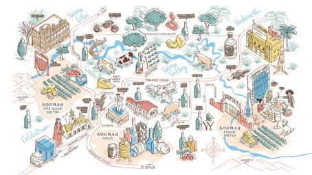
This illustrated map of the Yarra Valley region, created by Melbourne-based creative Kat Chadwick, presents a detailed hand-drawn guide to local vineyards, wineries, and regional landmarks. The piece employs a whimsical, cartographic illustration style with fine line work and gentle pastel accents in blue, red, and green. Various vignettes depict wine bottles, grape harvests, livestock, tractors, buildings, and figures dining outdoors. Hand-lettered place names and winding roads connect different locales across the illustrative landscape. The overall aesthetic is clean and artistic, combining clear informational layout with charming illustrative detail.