
Stephanie Ginger, Illustrator, London
Associated creatives

Tags
Description
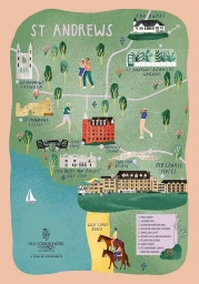
This illustrated map of St Andrews features a textured green and blue color palette showcasing various local landmarks, buildings, and coastal elements. The artwork depicts notable sites such as St Andrews Cathedral, St Andrews Castle, the Old Course Hotel, and the Swilcan Bridge, connected by winding paths. Small illustrated figures engage in activities like walking, jogging, golfing, and horseback riding across the green terrain. The piece is rendered in a charming, graphic style with visible grain textures throughout the land and water surfaces. Typography labels key locations across the map, with a small sailboat visible in the coastal water area on the left.